Area Restriction Expanded for Gladstone Park Wildfire

By Contributor
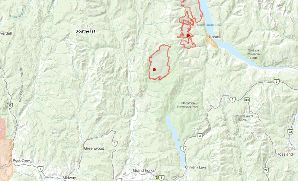
The BC Wildfire Service continues to respond to the Gladstone Park wildfire , which originated 34 kilometres north of Christina Lake in the Boundary fire zone.
The fire is currently estimated at 4,216 hectares in size. The existing Area Restriction Order in the vicinity of the Gladstone Park wildfire has been expanded.
The continued need to protect public and responder safety in Gladstone Provincial Park is the reason for the expansion of the Area Restriction.
In the interest of public and responder safety, an area restriction is now in effect:
- Commencing at Lynch Creek Forest Service Road (FSR) at Lynch Creek,
- Northwest along North Fork Road to Burrell Creek FSR,
- East along Deadeye Creek Road to the northern boundary of Gladstone Provincial Park,
- South to Lewis Peak,
- Southwest following height of land to Lynch Creek FSR,
- West along Lynch Creek FSR back to the point of commencement.
Note:
- Travel along the Burrell FSR and travel up to the 7-kilometre mark of the Lynch Creek FSR is permitted; entrance into the restricted area from Lynch Creek FSR is prohibited.
- Travel along the North Fork Road is permitted.
- Recreation and other activities are permitted along the Granby River.
- Camping adjacent to the North Fork Road and Burrell FSR is permitted.
- Access along the Bunchgrass and Knappen Creek FSRs and entrance into the restricted area is prohibited.
Under this Order and section 11(2) of the Wildfire Act, a person must not remain in or enter the restricted area, unless the person:
1. first receives written authorization of an official designated for the purposes of the Wildfire Act, or
2. enters the area only in the course of:
a. travelling to or from his or her residence, that is not under an evacuation order;
b. using a highway as defined in the Transportation Act;
c. travelling as a person acting in an official capacity as defined in s.56 of the Wildfire Act; or
d. travelling for the purpose of supporting wildfire suppression or enforcement patrol activities.
A detailed map of the affected area is available below and online: http://ow.ly/poum30rPSqQ.
Road closures and area restrictions are subject to change depending on fire activity. For the most current information please visit the bans and restrictions section of the BC Wildfire website for the Southeast Fire Centre, or visit: http://ow.ly/ILP230rPS7h.
To report a wildfire, unattended campfire or open burning violation, call 1 800 663-5555 toll-free or *5555 on a cellphone. For the latest information on current wildfire activity, burning restrictions, road closures and air-quality advisories, visit: http://www.bcwildfire.ca or download the BC Wildfire App free for Apple and Android devices.
The Southeast Fire Centre extends from the U.S. border in the south to Mica Dam in the north, and from the Okanagan Highlands and Monashee Mountains in the west, to the B.C.-Alberta border in the east.