Smoky Skies Bulletin amended for Boundary, West Kootenay
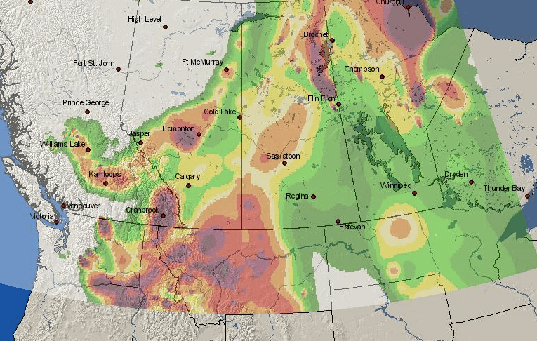
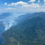
Smoke from wildfires in BC and south of the 49th parallel has forced Environment Canada to amend the area covered by the Smoky Skies Bulletin that was last updated on Monday August 28 due to changing conditions.
The Areas now covered by this Bulletin includes Arrow Lakes – Slocan Lake, Boundary, West and East Kootenay, Elk Valley and Kootenay Lake as well as 100 Mile House, Cariboo North (including Quesnel), Cariboo South (including Williams Lake), Chilcotin, East Columbia, Kinbasket, McGregor, Nicola, North Columbia, North Thompson, Okanagan, Prince George, Shuswap, Similkameen, South Thompson, West Columbia, Yellowhead and Yoho Park – Kootenay Park.
The Smoky Skies Bulletin also includes Southern Alberta, Southern and Northern Saskatchewan as well as Northern Manitoba and some of Ontario.
“Smoke concentrations will vary widely as winds, fire behaviour and temperatures change,” the Environment Canada website said.
“Avoid strenuous outdoor activities. If you are experiencing any of the following symptoms, contact your health care provider: difficulty in breathing, chest pain or discomfort, and sudden onset of cough or irritation of airways. Exposure is particularly a concern for infants, the elderly and those who have underlying medical conditions such as diabetes, and lung or heart disease.”
Environment Canada said this bulletin will remain in effect until further notice.
“Individuals may experience symptoms such as increased coughing, throat irritation, headaches or shortness of breath. Children, seniors, and those with cardiovascular or lung disease, such as asthma, are especially at risk.
“People with lung diseases, such as asthma and COPD, can be particularly sensitive to air pollution. They will generally experience more serious health effects at lower levels. Pollution can aggravate their diseases, leading to increased medication use, doctor and emergency room visits, and hospital visits.”
Environment Canada said people with breathing difficulties should stay inside and find an indoor place that’s cool and ventilated.
“Using an air conditioner that cools and filters air may help. If you open the windows you may let in more polluted air. If your home isn’t air-conditioned, consider going to a public place (library, shopping mall, recreation centre) that is air-conditioned.”
For more information on current air quality, see: www.bcairquality.ca.
The public can also check the Smoke Forecast website to track the smoke through Western Canada.
Forest service road closures in Southeast Fire Centre
In the East Kootenay part of the Southeast Fire Centre, the BC Wildfire Service has closed three forest service roads near active fires to help protect public safety and assist firefighting operations.
Lamb Creek wildfire:
- As of the afternoon of Aug. 30, 2017, the Lamb Creek wildfire (about five kilometres northwest of the community of Moyie and 18 kilometres southwest of Cranbrook) covered about 60 hectares.
- Thirty-four personnel are on site building fire guards with the assistance of heavy equipment, airtankers and helicopters.
- The Lamb Creek Forest Service Road has been closed, starting at the 1.5-kilometre mark of the Mineral and Lamb Creek Forest Service Road to the Whitney and Irishman Creek Forest Service Road junction.
- A map of the affected area is available online: http://ow.ly/SnGm30eNyMn
- The area restriction for Moyie Lake that was implemented on Aug. 29 remains in place.
Mount King George wildfire:
- As of the afternoon of Aug. 30, 2017, the Mount King George wildfire (about 49 kilometres northeast of Invermere) covered about 100 hectares.
- The Palliser Forest Service Road has been closed starting at the 54.25-kilometre mark.
- A map of the affected area is available online: http://ow.ly/iRjr30eNC07
Quinn Creek wildfire:
- As of the afternoon of Aug. 30, 2017, the Quinn Creek wildfire (east of the Top of the World Provincial Park and about 34 kilometres northwest of Sparwood) covered about 1,282 hectares.
- Seventy-two personnel are working on this fire with the assistance of heavy equipment and a helicopter.
- The Quinn Creek Forest Service Road has been closed, starting at the 60-kilometre mark at the Bull River Junction Forest Service Road.
- A map of the affected area is available online: http://ow.ly/2Qp430eN86M
The Southeast Fire Centre extends from the U.S. border in the south to the Mica Dam in the north and from the Okanagan Highlands and Monashee Mountains in the west to the B.C.-Alberta border in the east. The Southeast Fire Centre includes the Selkirk Natural Resource District and the Rocky Mountain Natural Resource District.


