High Streamflow Advisory: West Kettle, Kettle and Granby Rivers
UPDATE:
Environment Canada weather forecast is for the warm weather to hold through Saturday, with a cooling trend starting Sunday with the possibility of showers. Temperatures expected to be in the low 20’s Wednesday through Friday next week.
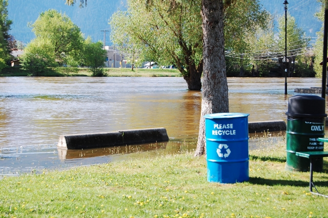
The River Forecast Centre provided the Regional District of Kootenay Boundary (RDKB) with the following summary this morning – entering tail end of snow melt from hot weather. The rate of rise has slowed down and the Kettle and Granby rivers are expected to pulse 5 to 10 cm over the weekend with the Kettle at a 2-year return level and a possibility of the Granby going to a 5-year return level. Systems are expected to stay 50 cm below 2006 levels. The High Stream Flow Advisory for the West Kettle, Kettle and Granby Rivers and Tributaries will stay in effect till Monday. Dependent on what level of participation we receive in the boundary basin there may be a possibility of going to a flood advisory early next week.
The RDKB Emergency Program continues to be activated at level 1 allowing staff to respond to requests for sandbags from residents. Staff will continue to monitor river levels, Weather forecasts and BC River Forecast advisories and provide updates as required.
Residents are reminded to stay away from river banks and be aware of large debris in the rivers. High water levels can push logs and other large debris into the river increasing the danger to people.
ORIGINAL STORY
The BC River Forecast Centre is issuing a high streamflow advisory for the Boundary rivers including the West Kettle, Kettle, Granby Rivers and their tributaries.
Several days of high temperatures has led to rapid melt of this season’s snow pack. River levels have been rising quickly in response to this melt. Current river levels are below levels of concern, however the weather forecast from Environment Canada is fo rsteady increases in temperatures in the South Interior through Friday.
River levels are expected to continue to increase through the remainder of the week,reaching the highest levels late on Friday or into Saturday.
With temperatures forecasted to ease slightly over the weekend, river levels may ease slightly into Sunday.
The River Forecast Centre will continue to monitor conditions and will provide updates as conditions warrant.
The Regional District of Kootenay Boundary is monitoring the situation and will alert residents if sandbags are needed. Residents are reminded to stay away from river banks and be aware of large debris in the rivers. High water levels can push logs and other large debris into the river increasing the danger to people.


