New snow not an invitation - avalanche warning high

By Contributor
The Canadian Avalanche Centre is issuing a special avalanche warning for the southern Selkirk and Monashee Mountains, the Kootenay-Boundary area, and the Southern Chilcotin Mountains. This warning is in effect for this coming weekend, Saturday March 13 and Sunday March 14. For a map of the affected areas, please go to: http://www.avalanche.ca/cac/bulletin/region-map/spaw-map.
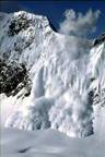
BC’s southern interior is forecast to receive its first real snow storm in almost eight weeks. The avalanche danger will be caused by storm snow overloading weak layers in the upper snowpack, explains CAC Avalanche Forecaster Greg Johnson.
“We have been tracking these weak layers since they formed in late January and in a normal winter they would be history by now,” says Johnson. “But with the lack of snow we’ve had this year, these layers are remaining very active and backcountry users are triggering avalanches fairly regularly. We’ve had a lot of close calls recently and, although this new snow will be tempting, the avalanche conditions in these areas will be very dangerous.”
The CAC has compiled an online photo album of recent avalanches triggered on the same weak layers identified in this warning. This resource can be found here: http://www.avalanche.ca/cac/march2010. Up to date information about avalanche safety, education, and conditions is always available at: www.avalanche.ca.