UPDATED: Evacuation Alert ends for Harrop, Proctor, Sunshine Bay, Kootenay Lake Village

By Nelson Daily Staff
The Regional District of Central Kootenay said in a media release Wednesday that BC Wildfire Service feels the threat posed by the Harrop Creek wildfire has diminished enough to rescind the Evacuation Alert for all residents in the communities of Harrop, Procter, Sunshine Bay, and Kootenay Lake Village, effective immediately.
To all RDCK residents, businesses and visitors in the area, please sign up to the RDCK Emergency Alert system which will inform users if a call to action is necessary in the event of an emergency or disaster.
The RDCK would like to thank residents for their cooperation, and to all the agencies involved including BC Wildfire Service for their continued hard work and dedication.
Return of cool weather helps BC Wildfire crews — off-road vehicle prohibitions rescinded
The Southeast Fire Centre said in a media release Tuesday the recent downturn in the weather has decreased the number of new wildfire starts and reduced aggressive wildfire behaviour the region, allowing initial attacks on any new wildfires to be successful.
“Increased visibility has allowed for more accurate mapping of wildfires in the Southeast Fire Centre,” the media release said.
“Several of the fires below have not experienced significant growth in several days.”
The BC Wildfire Service also announced that operation of off-road vehicles will once again be permitted on Crown land throughout the Southeast Fire Centre as well as the Cariboo Fire Centre and Kamloops Fire Centre, effective at noon on Wednesday, September 20, 2017.
The BC Wildfire Service said cooler weather conditions and recent precipitation have reduced the flammability of fine fuels in these regions, which has significantly reduced the chance of a wildfire starting from a spark or a hot engine.
However, the BC Wildfire Service reminds the public that some area restrictions are still in effect on Crown land in the vicinity of large wildfires in the Cariboo Fire Centre, Kamloops Fire Centre and Southeast Fire Centre, to help protect public safety and allow firefighting operations to continue efficiently. The use of off-road vehicles will continue to be prohibited in the restricted areas around these wildfires.
Updates on recent wildfire activity (as of the afternoon of Sept. 19, 2017):
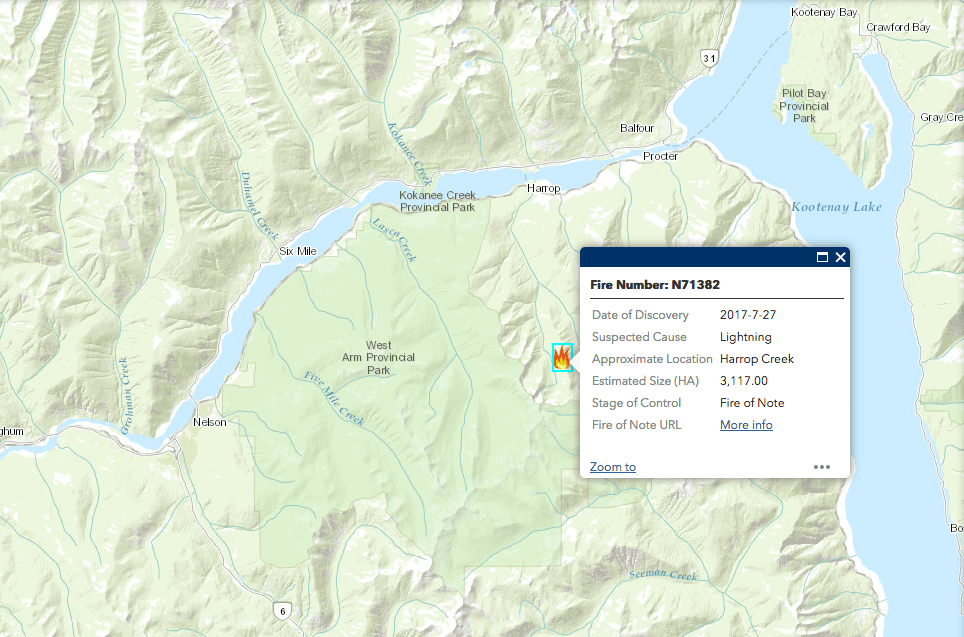
- The Harrop Creek wildfire, about 4.5 kilometres south of the communities of Harrop and Procter, covers about 3,117 hectares and is 10% contained. This fire has not experienced any significant growth in recent days. To assist firefighting activities, the Harrop Mainline Forest Service Road and East Harrop Mainline Forest Service Road closures are still in effect. In the interest of public safety, the Regional District of Central Kootenay has implemented an evacuation alert for Harrop, Procter, Sunshine Bay and Kootenay Lake Village. For detailed information about this evacuation alert, people should call the Regional District of Central Kootenay at 250 352-6665 or visit the districts website at: www.rdck.ca
- The Galena wildfire is about five kilometres east of Galena Bay and covers about 445 hectares. It is 60% contained and is being held.
- The McCormick Creek wildfire is about 30 kilometres southeast of Trail in the Pend D’Oreille area and covers about 410 hectares. It is 100% contained and is under control.
- The Lamb Creek wildfire is about 2.5 kilometres northwest of the community of Moyie and 18 kilometres southwest of Cranbrook. This fire covers about 2,157 hectares and is currently 50% contained. There are 113 firefighting personnel and an Incident Management Team on site today, supported by 15 pieces of heavy equipment, four helicopters and additional air support as needed. The existing closure of the Lamb Creek Forest Service Road has been expanded to include the Etna Creek Forest Service Road from the 0.5-kilometre mark to the Lamb Creek Forest Service Road junction and includes all its tributaries. A detailed map showing the area affected by this road closure is available online: http://ow.ly/LuJt30ffypF For more information about this fire, please call Fire Information Officer Marg Drysdale at 250 927-4637.
- The White River wildfire is about 37 kilometres northeast of Canal Flats. This fire covers about 26,400 hectares and is currently 90% contained and being held. Today, Sept. 19, there are 164 firefighting personnel on site with four pieces of heavy equipment, two helicopters and an incident management team. An area access restriction is in effect around this fire, along with several forest service road closures.
- The Linklater Creek wildfire is burning on both sides of the Canada-United States border, about 18 kilometres southwest of Newgate. This Canadian portion of this fire covers about 1,285 hectares. Today there are 34 firefighting personnel on site, supported by seven pieces of heavy equipment. An area access restriction is in effect around this fire.
- The Quinn Creek wildfire is located in the Bull River drainage, 30 kilometres west of Elk River and 60 kilometres northeast of Cranbrook. This fire covers about 11,764 hectares. There are 17 firefighting personnel on site today, supported by two pieces of heavy equipment. An area access restriction is in effect around this fire.
- The Kenow Mountain wildfire is located in the Flathead Valley, 20 kilometres west of Waterton, Alta. It is burning on both sides of the B.C.-Alberta border and covers about 38,152 hectares, of which about 15,449 hectares are in B.C. There are 16 firefighting personnel on site today. An area access restriction is in effect around this fire. More information about this fire is available online at: http://www.pc.gc.ca/en/pn-np/ab/waterton/securite-safety/feu-fire-kenow
- The Soowa Mountain wildfire in the Flathead Valley is about 60 kilometres southeast of Cranbrook and covers about 5,800 hectares. Today there are 29 firefighting personnel on site, supported by three helicopters and seven pieces of heavy equipment. An area access restriction is in effect around this fire.
- The Lodgepole Forest Service Road wildfire is about 25 kilometres east of Elko and covers about 2,263 hectares. Today, 32 personnel are on site conducting mop-up operations. An area access restriction is in effect around this fire.
For information on the area access restrictions that apply to fires in the Rocky Mountain Forest District under Section 11 of the Wildfire Act (including detailed maps and road closure information), please visit: http://ow.ly/YhPv30fhBeI
The Southeast Fire Centre extends from the U.S. border in the south to the Mica Dam in the north and from the Okanagan Highlands and Monashee Mountains in the west to the B.C.-Alberta border in the east. The Southeast Fire Centre includes the Selkirk Natural Resource District and the Rocky Mountain Natural Resource District.
To report a wildfire or open burning violation, call *5555 on a cellphone or 1 800 663-5555 toll-free. For the latest information on current wildfire activity, burning restrictions, road closures and air quality advisories, visit: www.bcwildfire.ca
You can also follow the latest wildfire news on:
* Twitter: http://twitter.com/BCGovFireInfo
* Facebook: http://facebook.com/BCForestFireInfo