City looks to floodplain report, grant application, to deal with rising flood issues

By Timothy Schafer
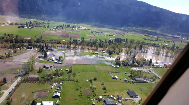
A new flood plain report delivered to the city recently is expected to lay the groundwork for the stemming of the tide of swollen spring floodwaters that have annually threatened large areas of Grand Forks.
The Grand Forks Floodplain Risk Management and Protection Project conducted by Urban Systems and delivered to city council last week contained 32 pages of flood-related issues the city will need to look at in developing a floodplain protection strategy.
With a significant portion (30 per cent or 325 hectares) of the city — as well as 1,523 ha. of the surrounding rural area — within the designated 200-year floodplain, the need for proactive work has arisen with both the Kettle and the Granby rivers now presenting ongoing risks of channel avulsion (river migration) or flooding.
“Recent flooding tested emergency response and coordination efforts and highlighted uncertainty around current flood hazards and their effects on property and critical infrastructure,” read a city staff report to council.
Currently, two standard dikes protect parts of the city. However, according to city staff, there are known deficiencies in the dikes as both were designed under older standards and suitability for protecting from future flooding was unknown.
In addition, floodplain mapping was over 25 years old and was based on even older hydrology and surveying data.
“Modelling was sufficient for engineering standards at the time, but new flood assessments need to incorporate new modelling methods and information on climate change and land development,” read a city staff report to council.
The grant would cover the first phase of the multi-year project, beginning with a study of the region’s flood plain, said the manager of Development and Engineering, Dolores Sheets.
“This would be the first step and then we would look at costing for other years,” she said.
The city has put $50,000 aside already for 2017 for the beginning of the study, as well as another $50,000 for 2018. As well, the city will be putting $50,000 into the budget for 2021 and 2023 with the intent to leverage that money for grant funding.
Although it is directly contributed money, Sheets said, it will be noted in the grant application that the city has put money aside for the project.
“That shows them we are well on our way with this project, and it shows well for our community,” she said.
Coun. Beverley Tripp applauded the report.
“This shows a really proactive approach to our needs in this area; certainly we’ve seen that this spring with all of the flooding,” she said.
But she questioned some costs suggested in the report, particularly the community engagement costs of around $30,000.
“This is a huge issue. It involves our entire downtown core, it involves Interfor, it involves Roxul. There is so much landmass that is in the flood plain that there is going to have to be substantial public outreach on this topic,” said Sheets.
On May 29 during its regular meeting council approved a motion to support city staff to proceed with preparing and submitting an application for the Gas Tax Strategic Priorities Program grant for 100 per cent funding of phase one of a three-phase, multi-year floodplain study and flood protection program for the Grand Forks flood plain.
The grant is available for infrastructure and capacity building projects that are either large in scale, regional in impact or innovative.
The city will submit a proposal in support of a long-term floodplain study and floodplain protection program for capital improvements to dike and flood protection infrastructure and related planning and emergency management needs.
Flood-related issues
The report highlighted a need to update the hydrologic analysis and peak flow estimates for the Kettle and Granby Rivers in Grand Forks, as well as the hydraulic analysis used to establish flood levels in the two rivers.
There is also a need to better understand existing flood hazards and risks to existing development, property, and critical infrastructure, as well as an assessment of future development plans and land use intensification near river channels to reduce flood hazards and avoid creating new problems, and an assessment of the options available for dealing with existing risks.
The report noted the city must further establish a range of suitable, efficient, and cost effective measures for dealing with flood hazards. Those measures included potential solutions such as identifying hydraulic improvements at crossings of creek channels (bridges and culverts), erosion protection through bank armoring, flood protection through more dikes or improving existing dikes, and emergency response strategies related to debris management during flood conditions.
A long-term capital improvement plan must also be developed for the city, aimed at upgrading the performance of the existing drainage system, and any non-structural mitigation plans — such as a bylaw aimed at flood hazard protection — must be identified.
Central to the entire flood hazard study is a computer model creation, developing a hydraulic model of the selected segments of river channels within the study area.
The work includes incorporation of all “topographic, geometric, geomorphologic and hydrologic data into a single, calibrated, backwater model that accurately represents flood conditions,” with estimated flow depths and velocities.